Home
Council on Energy, Environment and Water Integrated | International | Independent
Issue Brief

Managing India’s Air Quality Through an Eye in the Sky

L. S. Kurinji, Tanushree Ganguly
January 2020 | Clean Air

Suggested citation: Kurinji, S. L., and Tanushree Ganguly. 2020. Managing India’s Air Quality Through an Eye in the Sky. New Delhi: Council on Energy, Environment and Water.

Overview

This brief evaluates the merits of using satellite observations in aiding air quality management. It also identifies challenges in the effective application of satellite observations. By providing insights into the scope of use of satellite data for air quality applications, it recommends the way forward for key stakeholders, policymakers, and researchers.

Given the high upfront cost of setting up continuous monitoring stations, there is a strong need for identifying approaches that complement ground monitoring. Satellite observations have been used globally to track air quality and plug geographical blind spots.

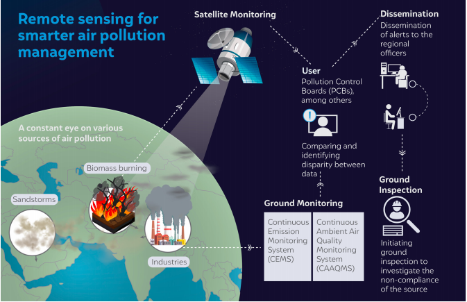
Source: Authors' compilation

Key highlights

  • Satellite observations can be used for acquiring spatially continuous data on pollutants, identifying airsheds, pollution hotspots, transboundary and episodic pollution sources and triggering inspections at industrial units and power plants
  • The wide spatial coverage of satellite remote sensing can help to fill the data gaps that exist due to the vast geography
  • Sudden variations in satellite observations, if identified during regular monitoring and found to correspond with the location of large industries or power plants, could initiate an inspection
  • The government can use satellite data to identify the air shed covering all the air pollution sources that influence a city’s air quality and can devise regional air quality management strategies to mitigate the impact of air pollution drift
  • Satellite data can also be used as evidence to demonstrate the negative impact on air quality caused by exceptional events like forest fires and dust storms, as the impact of these cannot be captured by traditional ground monitoring systems
  • The primary challenge in effective application of satellite observation is a lack of technical capacity to accurately interpret data in order to derive insights
  • Secondary challenges include the lack of infrastructural capacity to store and process large volumes of satellite data and the unavailability of reliable ground information for validating the satellite observations.

Key recommendations

  • Build capacities for the potential use of satellite data on air quality
  • Envision launching a geostationary satellite to specifically monitor air quality
  • Make indigenous satellite-derived products easily accessible for public use

“Fires, dust storms, aerosols – satellites see it all. The air quality management framework in India would remain incomplete without the integration of satellite-based observations.” - Tanushree Ganguly.

Sign up for the latest on our pioneering research

Explore Related Publications