Council on Energy, Environment and Water Integrated | International | Independent
Suggested citation: Mohanty, Abinash and Vidur Mithal. 2022. Managing Forest Fires in a Changing Climate. New Delhi: Council on Energy, Environment and Water.
This study presents a micro-level assessment of forest fires by identifying the states most vulnerable to high-intensity forest fires and their district hotspots while taking climate change indicators into consideration. The study also investigates the impact of forest fires on local air pollution. The study argues that a comprehensive assessment at a localised level can help mitigate forest fires.
There is no denying that in a warming and increasingly changing climate, forest fires are likely to intensify at an unprecedented scale, disrupting the ecological and socio-economic fabric of the country. Globally, fires are used as a forest management tool; however, rapid changes in climate and meteorological variables (high temperatures, inadequate precipitation, and wind speed anomalies) are fanning forest fires across the globe and in India as well (FAO 2020). Indian forests have the potential to sequester an additional 3 billion tonnes of CO2 equivalent by 2030 and ensure livelihoods for 22 per cent of the population (275 million) who rely on forests for their sustenance (Sharma 2018). India as part of the Bonn Challenge at the Conference of the Parties (COP) 15 committed to restoring 13 million hectares of its degraded forests by 2020, and an additional 8 million hectares by 2030 – which was enhanced to 26 million hectares in 2019 (PIB 2019). There is plenty of scope to improve the management of forests – primarily to protect against the impacts of climate change, increase in the incidents of forest fires, deforestation, and forest diversions, among others. About 36 per cent of forest cover in India falls under extreme, very high, high, and moderate forest fire– prone zones (FSI 2019).
Our study presents a micro-level assessment of forest fires by identifying the states most vulnerable to high-intensity forest fires and their district hotspots while taking into consideration the warming and varying climate. The study also investigates the impact of forest fires on local air pollution. We use multi-decadal (2000–09|2010–19) spatiotemporal analysis to identify the high-intensity forest fire vulnerable states and their correlation with the varying microclimate.
The study argues that a comprehensive assessment for forest fires by integrating climatological scenarios at a localised level can help mitigate forest fires better. Our analysis suggests that there has been a 10-fold increase in forest fire incidences in the last two decades, whereas the total forest cover (TFC) has only increased by 1.12 per cent. Our analysis further suggests that tropical moist deciduous forests, followed by tropical dry deciduous forests, are most vulnerable to forest fires.
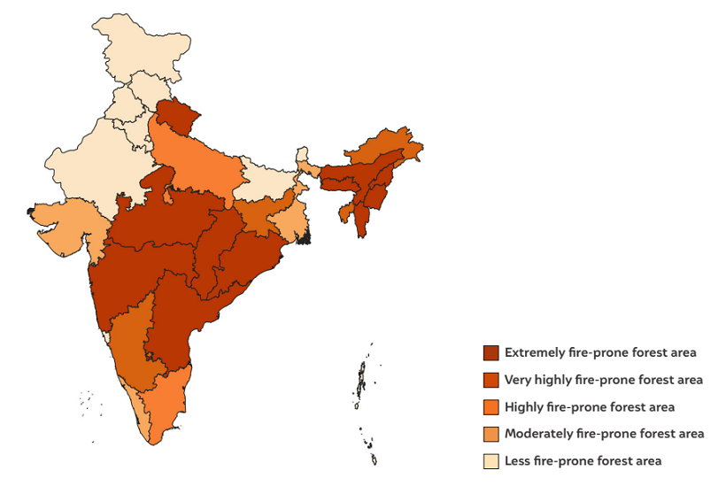
Source: Authors’ analysis
Note: The base map shapefile is based on India’s 2011 Census and, therefore, does not represent current states / UTs boundaries.
Our study finds that more than 30 per cent of all Indian districts, home to more than 275 million people, are extreme forest fire hotspots. Andhra Pradesh, Odisha, Maharashtra, Madhya Pradesh, Chhattisgarh, Uttarakhand, Telangana, and the north-eastern region (NER) states – except for Sikkim – are prone to highintensity forest fire events. In the decade 2000–09, more than 58 per cent of Indian states were exposed to high-intensity forest fire events; among these states, 34 per cent were exposed to extreme forest fires; 13 per cent to very high intensity; and 10 per cent to high intensity forest fires, respectively.
Similarly, in the decade 2010-19, more than 65 per cent of states are exposed to high-intensity forest fire events, out of which 41 per cent are exposed to extreme forest fires, 13 per cent to very high, and 10 per cent to high forest fires, respectively. Further, table below represents the forest fire hotspot states and districts based on our multi-decadal analysis (2000-09 | 2010-19).
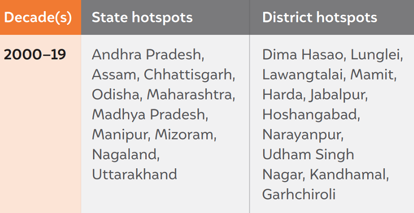
Source: Authors’ analysis
We performed a spatio-temporal analysis to map the forest fire hotspots on a downscaled Köppen classification of climate zones. To understand the correlation between forest fire hotspots and varying microclimates, we use the base-level microclimate zone variation maps from Mohanty’s (2020) microclimate zone analysis to derive an understanding of forest fire incidents across different microclimate zones. Our analysis suggests that most forest fire incidences are occurring across districts that are drought hotspots or are increasingly showing a swapping trend (traditional flood-prone areas becoming drought-prone). Further, this confirms that drought or drought-like conditions are marked by increased dry spells, which are consequently intensifying forest fires. Kandhamal (Odisha), Sheopur (Madhya Pradesh), Udham Singh Nagar (Uttarakhand), and East Godavari (Andhra Pradesh) are some of the forest fire hotspot districts that are also showing a swapping trend from flood to drought. Figure 5 maps the extreme forest fire–prone areas across varying microclimate zones. The forest fire district hotspots are primarily located in the Cwa , Bsh, Am, and Aw climate zones. More than 79 per cent of the forest fire hotspots lie in the Cwa and Aw climate zones.
We also investigated the impact of changing forest fire patterns on local air pollution. Looking at the values for aerosol optical depth (AOD), we find that the onset of the fire season results in an increase in AOD, indicating higher levels of hazardous particulates in the atmosphere. This trend is observed for all the leading forest fire hotspots except Harda, Madhya Pradesh, wherein several factors may obscure results from this analysis. We also found the trend to be weaker in 2020, possibly owing to relatively fewer fires in that year and an above-average 2019 monsoon.
We recommend applying the principles of risk assessment and acknowledging forest fires as a chronic hazard at the core of India’s strategy. Our recommendations to climate-proof forests are as follows:
Roadmap of the methodology to assess the climate co-benefits of the SUP ban in Tamil Nadu
Unlocking finance for NbS in Indian Cities
Locally-led Climate Action in the Global South
Towards Climate-resilient Indian Industries:
Roadmap of the methodology to assess the climate co-benefits of the SUP ban in Maharashtra