Council on Energy, Environment and Water Integrated | International | Independent
About 75 per cent of India’s total rainfall comes from the southwest monsoon rainfall, making it essential for agriculture, the economy, and water security. Given that nearly half of India’s agriculture depends on rainfed agriculture, the timing and the progression of the monsoon are critical. An early or delayed monsoon can affect crop yields. This year, the southwest monsoon arrived early in Kerala on 24 May 2025, eight days before the usual date of 1 June, marking its earliest onset since 2009. However, as of early June, the monsoon has entered a break phase, and heatwave warnings have been issued across northern India.
So, what does an early monsoon onset really mean? While above-normal rainfall is forecast this monsoon (June–September), understanding its spatial and temporal distribution is crucial. In this blog, we explore whether an early onset impacts the distribution of rainfall for the rest of the season, including total rainfall and withdrawal dates, by examining data from the past 20 years based on the Indian Meteorological Department (IMD)’s monsoon reports. These changes have significant implications for the Indian economy as a whole and key sectors such as agriculture, water resources, and disaster management, compelling us to understand how India’s monsoon is evolving in an era of accelerated climate change.
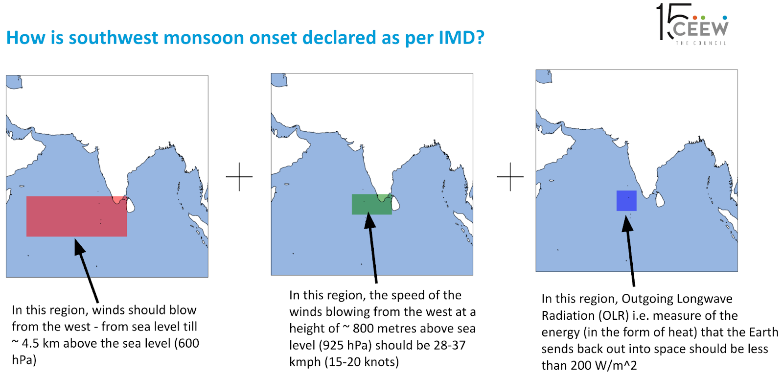
Let us look at how the monsoon onset is officially declared. In India, the arrival of the Southwest Monsoon is marked by its landfall over Kerala. But it is not as simple as the first few showers. IMD follows a set of scientific criteria—including patterns of rainfall, wind, and cloudiness—to confirm that the monsoon has truly arrived.
First, 60 per cent of the following 14 stations—Minicoy, Amini, Thiruvananthapuram, Punalur, Kollam, Alappuzha, Kottayam, Kochi, Thrissur, Kozhikode, Thalassery, Kannur, Kudlu, and Mangalore—must report rainfall of 2.5 mm or more for two consecutive days after 10 May. The onset over Kerala is then declared on the second day, provided the following criteria (as seen in Figure 1) are also met in concurrence.
Figure 1: IMD criteria for declaration of monsoon onset over Kerala
Source: Authors’ visualisation based on IMD criteria
If all these conditions are met, the IMD officially declares the onset of the monsoon over Kerala. From there, the monsoon advances northward into India, eventually covering the entire country in the weeks that follow.
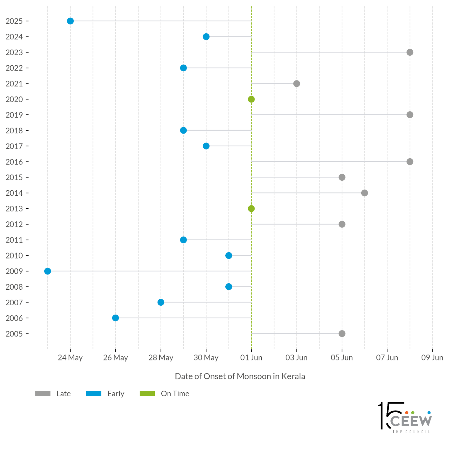
Figure 2: Frequent early arrivals: Southwest monsoon advanced ahead of schedule in 11 of the last 20 years, more prominently in 3 of the past 5 years
Source: Authors' analysis based on IMD monsoon reports
Figure 2 compares the monsoon onset dates each year with the typical onset date of 1 June. The blue, green and grey dot denotes an early, on-time, and delayed arrival of monsoon respectively. Between 2005-2025, the earliest onset occurred on 23 May (9 days early) in 2009, and then in the current year, 2025, on 24 May (8 days early).
Monsoon onset dates in Kerala over the past 20 years show significant variability. In more than half of these years, the monsoon arrived earlier than the expected date of 1 June, while in 8 years, it was delayed. While it has been established by various studies that the early onset dates do not correlate with the seasonal rainfall received, it might have some influence on the intensity of rains during June. The early onset also impacts the agricultural sector in India, damaging crops like those in Maharashtra in 2025, and is known to advance the sowing dates of kharif crops, such as rice and cotton, requiring an active response from the farmers.
While the exact reason is not known, the early arrival of the monsoon in India this year could be the result of several large-scale weather systems and oceanic processes working together. Here is what is happening:
No El Niño, no La Niña, but neutral conditions: The El Niño-Southern Oscillation (ENSO) is a global climatic phenomenon that has the ability to change the global atmospheric circulation, and this, in turn, impacts the temperature and precipitation across the globe. There are two extreme phases of ENSO: El Niño and La Niña, and a neutral phase. Generally, during an El Niño year, monsoon rainfall is weaker, while during a La Niña year, there is normal to above-normal rainfall. This year, neither is active — this is called a "neutral" condition. A neutral phase generally supports a normal or even slightly stronger monsoon. This phase is forecast to continue over the entire monsoon season. A study in Nature further notes that the influence of ENSO on summer monsoon rainfall is more pronounced in north and south India compared to the central Indian region. But ENSO is not the sole driver of monsoon patterns in India. In fact, this relationship between ENSO phases and monsoon rainfall is dependent on space and time. Thus, we need to look at factors other than ENSO phases to build a complete understanding of the monsoon onset.
Favourable conditions in the India Ocean for an early onset: Another factor that influences the onset of monsoon is the Indian Ocean Dipole (IOD), a climate pattern that influences rainfall in the region. It depends on where the ocean is warmer—either in the western or eastern Indian Ocean. In a positive IOD phase, warm waters move to the western Indian Ocean, while colder waters rise near the eastern side, leading to an increased rainfall, whereas in a negative phase, the pattern is reversed, causing a decline in rainfall. In a neutral IOD phase, temperatures are normal across the tropical Indian Ocean. In the last week of May 2025, a neutral IOD condition was observed, with a forecast of transitioning to a positive phase over the Indian Ocean. The IOD conditions, hence, are indicative of normal ocean and atmospheric conditions, making the conditions favourable for rainfall over the region.
The role of Madden-Julian Oscillation (MJO): The Madden-Julian Oscillation (MJO) is an eastward-moving system of winds, clouds, rainfall, and pressure that travels across the tropical regions, influencing weather patterns along the way. The MJO has the capacity to enhance rainfall in one of its phases. When the MJO is active, it brings more clouds south of India, which are then carried northwards by the monsoon winds. As of 22 May, the MJO was in phase 4 with moderate strength and is expected to move into phases 5 and 6 soon, which are the most dominant stages. This means it will likely help increase cloud formation and rain over the Arabian Sea and later over the Bay of Bengal.
Low-pressure system over the Arabian Sea: As of 24 May, a low-pressure area had formed over the Arabian Sea. This system acts like a magnet, pulling in moisture-laden winds, helping trigger rainfall, and pushing the monsoon inland.
In India, the IMD releases a seasonal forecast for southwest monsoon at the end of May. Further, after 30 September, the performance of the southwest monsoon is measured by comparing the total rainfall received during the season to a benchmark called the Long Period Average (LPA). The LPA is the average rainfall the country received during the monsoon months (June to September) over the past 50 years, from 1971 to 2020. Right now, the LPA is 87 cm (or 870 mm).
Once the season ends, the total rainfall is expressed as a percentage of the LPA. Based on how much more or less rainfall we got compared to this average, the monsoon is classified into these five categories, as seen in Figure 3.
Figure 3: Categorisation of monsoon performance
|
Category |
% of LPA Rainfall |
Meaning in simple terms |
|
Deficient |
Less than 90 |
Very little rain, much below average |
|
Below Normal |
90 to 95 |
Slightly less rain than average |
|
Normal |
96 to 104 |
Close to average rainfall |
|
Above Normal |
105 to 110 |
A bit more rain than usual |
|
Excess |
More than 110 |
Much more rain than the long-term average |
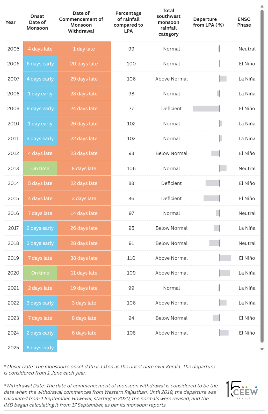
Figure 4: Monsoon onset and withdrawal dates show no consistent link with total seasonal rainfall.
Source: Authors' analysis based on IMD monsoon reports
As seen in Figure 4, based on the last 20 years of analysis, there is no clear link between the onset of monsoon and its quantum or withdrawal. Further, several studies of the Indian monsoon have established that there is no significant correlation between onset and total rainfall. For example, in 2017 and 2018, the monsoon arrived 2–3 days early, but the overall rainfall was still below normal. However, when the monsoon advances rapidly post onset and covers the entire country in a shorter time—regardless of the onset date—it has often led to excessive rainfall in some regions. For example, in 2013, when the monsoon arrived on 1 June and covered the entire country by 16 June, heavy rainfall was observed over Northern India, causing damage to life and property.
Over the past two decades the withdrawal of monsoon has been observed to be increasingly delayed. A study by CEEW found that nearly 48 per cent of India’s tehsils received more rainfall in October during 2012–2022 compared to the Long Period Average from 1982–2011, which could be attributed to the delayed withdrawal of the monsoon from the Indian mainland.
The IMD has issued a forecast for an above normal monsoon for 2025, over 106 per cent of the LPA. Yet, if the last few decades have taught us anything, it is that an early onset of the monsoon does not guarantee well distributed rain throughout the season. Onset dates have varied wildly, but show little correlation with either total rainfall or withdrawal timing.
However, there is another trend—a growing erraticness not just in when the rains begin and end, but also in how they behave across regions. Climate change is warming the atmosphere, increasing its moisture-holding capacity, which means increased frequency and intensity of heavy rainfall events. While years like 2017, 2018, 2022, and 2024 had an early onset, it did not translate into consistent rainfall patterns or outcomes. Such erratic behaviour is not just a weather anomaly — it carries serious implications for agriculture, water security, and the broader economy.
A recent study by CEEW, which mapped monsoon trends at the tehsil level from 1982–2022, revealed a significant shift in changing rainfall patterns. In the past decade alone:
This growing spatial and temporal variability of the Indian monsoon means that India must rethink how it prepares for it and increasingly erratic rains. An early onset may offer temporary relief from the heat season or an early sowing window for Kharif crops, but without flexible planning, it can just as easily bring disruption.
The IMD’s launch of the Bharat Forecast System (BharatFS) in May is a timely and welcome step. With its 6-km resolution, it can offer hyperlocal forecasts down to the panchayat level. But data alone won’t drive change. We need to revise cropping calendars, integrate climate forecasts into farm advisories and urban planning, and build local institutional capacity to act on this information to translate weather forecasts into impact-based early warnings for different sectors.
The southwest monsoon remains the heartbeat of the Indian economy. As climate change accelerates, our ability to understand, predict, and plan for its shifting patterns will define India’s climate resilience. A business-as-usual approach is no longer an option.
With inputs from Dr Rafiuddin Mohammad, Programme Lead, CEEW.
Keerthana A.S. is a Research Analyst, Anurag Sahu is a Research Consultant, and Shravan Prabhu is a Programme Associate at the Council on Energy, Environment and Water (CEEW). Send your comments to [email protected].


Add new comment