Council on Energy, Environment and Water Integrated | International | Independent
As the climate continues to change, it is undeniable that climate hazards are on the rise and will increase in frequency and intensity. According to an analysis conducted by the Council on Energy, Environment and Water (CEEW), almost 75 per cent of the districts in India are prone to extreme climate events. Unfortunately, this rise in hazards coincides with an increase in population and unsustainable land use, leading to more hazards becoming disasters. This makes it imperative to adapt new disaster management strategies. In this context, geospatial technology can play a crucial role. The use of geospatial technology in disaster management is a natural fit because almost every aspect of a disaster can be referenced by location. But in India, there is still a lag.
Geospatial data refers to records within a dataset that contain locational information, such as coordinates, addresses, and spatial patterns. As of 2022, India’s Union and state governments have collectively spent around INR 300 crore on geospatial components of their programmes (ISID 2022) . With a growth rate of 12.8 per cent, the Indian geospatial industry is projected to be valued at INR 63,000 crore by 2025 and will provide employment to more than 10 lakh people (National Geospatial Policy 2022). This is possible due to the 11th Five Year Plan (2007-2012), in which the use of geospatial technologies, with 8 per cent of the total project budget, was mandated in several infrastructure segments such as rural development, power, land and natural resources (ISID 2022). However, the use of geospatial technology in disaster management in India has not seen as much uptake as it should.
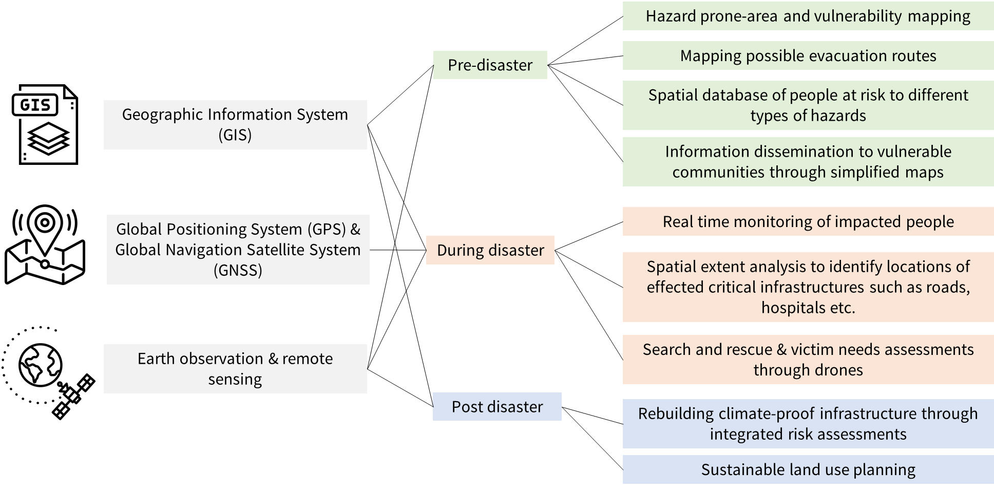
Figure: Geospatial technology has benefits in all three stages of disaster management
Source: Authors’ illustration
While the benefits of geospatial technology in disaster management are well known, there are several challenges in scaling up this technology in policy and decision-making. This primarily includes lack of knowledge and expertise to extract information from data, accessibility to fine-resolution data, and software and hardware challenges. To mainstream the use of geospatial technology and analysis across all stages of disaster and climate risk management, we suggest four measures.
First, make fine-resolution geospatial data from indigenous satellites openly available to overcome the reliance on external satellite sources. For instance, the Forest Survey of India (FSI) currently uses SNPP-VIIRS and MODIS for mapping forest fires, while Sentinel 1 is primarily used for mapping floods due to the absence of high spatio-temporal microwave remotely sensed data from Indian satellites. To facilitate path-breaking research and development of tools that will aid in effective disaster management, it is essential to make fine resolution data openly available from Indian satellites such as RESOURCESAT and CARTOSAT, which are among the finest resolution satellites in the world. This can be achieved through easy-to-use data sharing platforms such as the USGS earth explorer, Bhuvan and the Copernicus hub.
Second, increase the availability of open-source tools, platforms, and repositories to strengthen collaborative research and development. Private organisations, research institutions, and NGOs can work together to develop such resources that enable the sharing of data and analytical tools. The Indian research community can build upon international best practices, such as the United Nations Platform for Space-based Information for Disaster Management and Emergency Response (UN-SPIDER), which serves as a platform for using space-based technologies for disaster management and emergency response. UN-SPIDER offers easy-to-use training modules, tools, and capacity-building exercises focused on disaster management that are freely available on the platform.
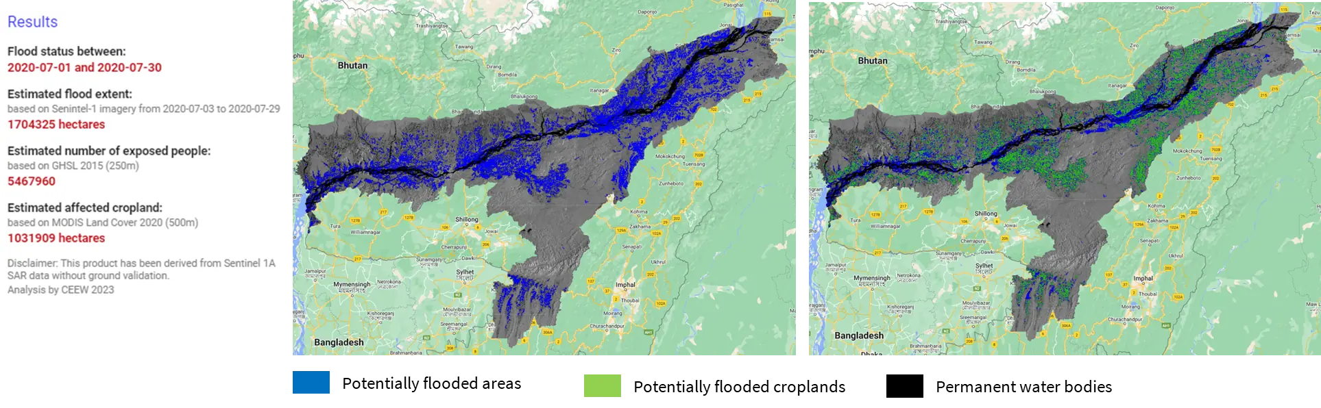
Figure: Mapping flooded areas and croplands during the Assam floods of July 2020 using Sentinel 1A Synthetic Aperture Radar (SAR) data
1The Suomi National Polar-orbiting Partnership (SNPP) Visible Infrared Imaging Radiometer Suite (VIIRS) is a satellite sensor that is owned and operated by the National Oceanic and Atmospheric Administration (NOAA) and the National Aeronautics and Space Administration (NASA) as part of a joint mission to study Earth's weather, climate, and environment.
2 MODIS (Moderate Resolution Imaging Spectroradiometer) is a key instrument aboard two NASA Earth Observing System (EOS) satellites, Terra and Aqua owned and operated by NASA and NOAA
3Sentinel-1, owned and operated by European Space Agency (ESA), is a constellation of two SAR satellites providing all-weather, day-and-night radar imaging of the Earth's surface as part of the Copernicus Programme.
4 SAR is a type of active data collection where a sensor produces its own energy and then records the amount of that energy reflected back after interacting with the Earth. Due to its ability to pierce through clouds and record data even during night time, it is preferred over optical imagery for mapping floods.
Source: Author’s analysis using modified version of UN-SPIDER script and Google Earth Engine
Third, enhance the capacity of government officials in utilising geospatial technology across different levels. At the entry and field level, officials must be equipped with the ability to decipher map visualisations and employ maps as a means of effective communication and outreach. For intermediate and advanced levels, it is beneficial to take advantage of initiatives such as the Disaster Management System Programme Capacity Building activities provided by the Indian Space Research Organisation (ISRO), which offers openly accessible courses to build technical capabilities. Additionally, maps being the simplest form of communication about any forthcoming climate risk, it is imperative to simplify spatial data terminology and make it jargon-free so that even policymakers without specific technical knowledge can utilise them for informed decision-making.
Fourth, since disaster management is a multi-sectoral approach, integration and sharing of spatial data integrated into Disaster Management Information System (DMIS) and other such platforms becomes crucial. This is particularly significant for departments such as agriculture, water, and health, which are the most affected during a disaster. To tackle these data-sharing challenges, the development of portals such as a spatial data infrastructure (SDI) integrated with the DMIS throughout government departments at a state level can be a viable solution. An SDI is a framework that connects spatial data, tools, and users interactively, facilitating the use and sharing of data in an efficient, dynamic, and flexible way. Following the triumph of India's National SDI, it is recommended that the states establish their own State SDIs along with the GIS labs in disaster management departments to mitigate the sectoral impacts of disasters.
India's goal to achieve net-zero carbon emissions by 2070 to mitigate climate change and develop adaptation strategies against disaster risks recognises the inevitability of extreme weather events. Nevertheless, technology can play a vital role in minimising their impact and reducing damage. With the rapid expansion of geospatial technology, disaster management authorities must seize this opportunity to enhance disaster risk reduction while simultaneously promoting jobs, growth, and sustainability. Although the National Geospatial Policy 2022's aim to democratise fine resolution datasets by 2030 and 2035 is a step in the right direction, urgent action is needed to address the escalating frequency of extreme weather events. As India leads the G20, geospatial technology sharing regarding should remain a point of collaboration among countries.
Shravan Prabhu is a Research Analyst at the Council on Energy, Environment and Water (CEEW).
Pritipadmaja is a PhD scholar at the Indian Institute of Technology, Roorkee and is working with CEEW as a part of Nav-i-GEE program. Send your comments to [email protected]


Add new comment