Council on Energy, Environment and Water Integrated | International | Independent
Up to 3°C above normal: Where Pacific sea surface temperatures are headed by November 2026, crossing into very strong El Niño territory
90%: of India could face below-normal rainfall this monsoon
~45 GW: of solar capacity added in FY2026—more than in any year before. El Niño may be the first serious test of what that means
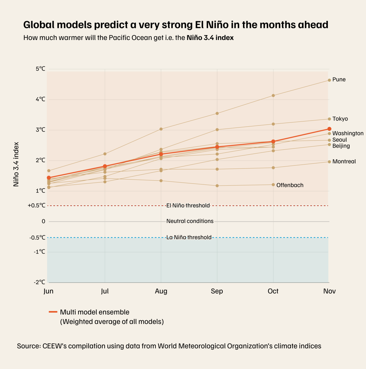
The Niño 3.4 is one of the indices scientists use to grade El Niño events: cross 0.5°C and El Niño has arrived; cross 2°C, and you are in very strong event territory—a categorically different season. Multi-model projections put the index at an average rise of 1.44°C in June, rising to 2.2°C by August. By November, the mean projection reaches 3°C in some models.
As we explored in Edition 1, CEEW's 40-year analysis shows the impact of the strong El Niño years on heat risk. It is a pattern that WMO's probabilistic modelling suggests will repeat this year. Every part of India is projected to face above-normal temperatures this June–August, with nearly half the country in the 70–80% probability band. And it’s not just the heat that is impacted.
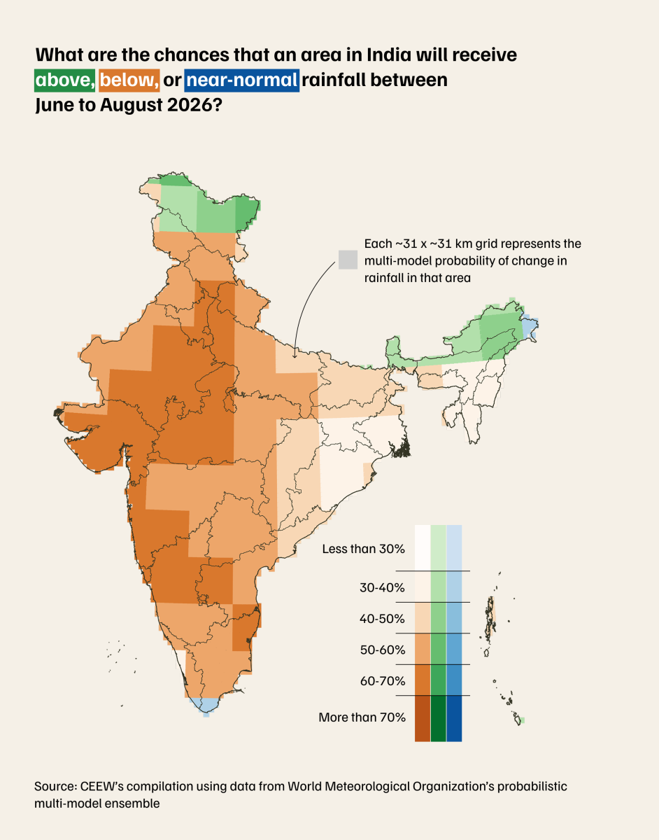
For 60% of India’s farmland, the monsoon is the only source of irrigation water. For the RBI, it is the single biggest variable in the inflation forecast. For most Indian households, it determines what food costs for the rest of the year. The IMD has forecast monsoon rainfall at 90% of the Long Period Average for 2026 (the official below-normal threshold) and WMO’s probabilistic modelling shows 90% of India is facing drier-than-normal conditions through June to August.
The reason goes back to how oceans and atmosphere are connected. The warming Pacific doesn’t stay local—it impacts wind patterns across thousands of kilometres (a process called atmospheric teleconnection). For India, this disrupts the gradient that drives the monsoon. The moisture flow from the Arabian Sea and the Bay of Bengal weakens. Fewer clouds form, and more solar radiation reaches the ground instead. The heat compounds, monsoon weakens.
Last year, India’s monsoon delivered 108% of its long-period average (IMD). This year’s models are pointing in the opposite direction.
The same El Niño threatening India’s monsoon is also turning up the heat on its electricity system. India hit 270.82 GW of peak power demand in May 2026. As temperatures and humidity climb through June and July, cooling demand climbs with them.
But here is what changes the picture. El Niño reduces cloud cover over India, which means more direct sunlight reaching the ground. The hottest, most cloudless days of the year are also the days solar generation runs strongest. The afternoon demand peaks that strain the grid hardest align almost precisely with peak solar output hours.
India added a record 44.61 GW of solar capacity in FY2026, with May recording an unprecedented 3+ lakh rooftop solar installations. The physics suppressing the monsoon could be, in the same breath, powering the solar panels.
What is the one system El Niño could expose first in India: farms, cities, grids, or food prices?
Written by: Shreya Kapoor
Research by: Evita Merin Xavier, Mohammed Rafiuddin
Charts by: Poojil Tiwari
Scroll into UpChart, our data-focused LinkedIn emailer that connects dots