Council on Energy, Environment and Water Integrated | International | Independent


Suggested Citation: Chatterjee, Ahana, Meet Kumar, Srishti Mandal, Taveri Rajkhowa, and Shreya Wadhawan. How Can Himalayan Communities Anticipate Risks and Adapt to a Changing Climate? Evidence from 12 gram panchayats in Himachal Pradesh. 2026. Council on Energy, Environment and Water.
Strategic foresight is a critical tool for advancing anticipatory adaptation, enabling communities, sectors and institutions to move beyond responding to climate impacts towards anticipating risks and preparing for their consequences. Himachal Pradesh is increasingly exposed to climate-related hazards, including rising temperatures, extreme rainfall, floods, landslides and forest fires. Between 2020 and 2025, these risks contributed to cumulative damage of INR 21,097 crore (USD 2.19 billion) and more than 2,000 casualties (HPSDMA Post Disaster Needs Assessment 2025). Their cascading impacts on lives, livelihoods, infrastructure, water security and mountain ecosystems call for an approach that moves beyond reactive disaster response. Anticipatory adaptation enables action before hazards escalate into disasters, helping identify locally relevant measures to reduce vulnerability and build resilience.
In Himachal Pradesh, communities are already taking steps to reduce disaster risks and adapt to a changing climate, with local initiatives offering valuable lessons for the future. Drawing on scientific evidence, local knowledge and collective intelligence, strategic foresight can build on these efforts to explore plausible futures, identify anticipatory adaptation solutions, and embed them in policies, plans and government schemes.
This study demonstrates how a bottom-up, forward-looking approach can strengthen long-term climate resilience across the Indian Himalayan Region (IHR). Drawing on inputs from 12 gram panchayats across Mandi, Kullu, Shimla and Sirmaur districts and a multi-stakeholder consultation, the study co-developed 25 anticipatory adaptation solutions across five critical sectors, and identified the institutions and government mechanisms that can scale them. The study thus positions Himachal Pradesh as a leading example for institutionalising anticipatory adaptation within the IHR. It demonstrates how strategic foresight can catalyse systemic, bottom-up climate resilience.
Background: The Himalayas are increasingly vulnerable to a changing climate
In August 2026, an ice-rock avalanche in Nepal's Rasuwa district triggered a catastrophic flash flood along the Bhote Koshi and Trishuli river systems (ICIMOD 2026a; USGS 2026), sweeping away homes, destroying villages, bridges and hydropower infrastructure across nearly 100 km downstream, and causing widespread loss of life (ICIMOD 2026b). Such an event is not an isolated anomaly. Across the Hindu Kush Himalayan Region, including the Indian Himalayan Region, a rapidly changing climate has led to a marked increase in the frequency and intensity of extreme climate events (ICIMOD 2019; Wester et al. 2023). As climate change increasingly interacts with urbanisation, environmental degradation and associated socio-economic shifts, climate risks will become increasingly complex and interconnected (Adler et al. 2022), threatening the quality of life of Himalayan communities, and also those of 1.9 billion people downstream (ICIMOD 2019). Adapting to these changes, reducing future loss and damage, and building resilience to future climate-induced impacts therefore requires not only understanding risks that mountain communities experience at present, but also anticipating how these risks may evolve, identifying potential impacts, and enabling adaptation before the risks materialise.
Strategic foresight can help bridge this gap by bringing together scientific evidence, local knowledge and multiple stakeholder perspectives to explore plausible futures and identify actions that can be taken today for a climate-resilient future (Copenhagen Institute for Future Studies 2024; United Nations Department of Economic and Social Affairs 2026).
Figure ES1. Foresight is the disciplined analysis of alternative futures.

This is the premise that this study builds on. It asks: How can Himalayan communities utilise strategic foresight to be able to anticipate and adapt to climate risks that may emerge in the future? And, how can they reduce disaster risk through collaboration between communities, government institutions, research organisations, and civil society, enabling effective, collective response?
The study thus illustrates how strategic foresight could be used to inform disaster risk reduction and climate adaptation. It deploys the strategic foresight approach in Himachal Pradesh, a climate-vulnerable state within the Indian Himalayan Region which showcases strong community knowledge and adaptive practices, and growing state-level emphasis on decentralised disaster How Can Himalayan Communities Anticipate Risks and Adapt to a Changing Climate? 5 risk management. It brings together perspectives from various actors using foresight tools. It thus explores future scenarios under conditions of uncertainty and complexity posed by the changing climate.
The Hindu Kush Himalayan (HKH) region, the world’s Third Pole, is warming twice as fast as the global average (ICIMOD 2019 and Sabin et al. 2020). Glaciers are disappearing 65 per cent faster than in the previous decade (Shrestha et al. 2015; ICIMOD 2023b; Wester et al. 2023), while 10 of its 12 major river basins have recorded significantly below-normal snow persistence for four consecutive years (Muhammad 2025). This has sharply increased the frequency and intensity of extreme climate events, including heatwaves, extreme precipitation, flash floods, cloudbursts, glacial lake outburst floods (GLOFs), landslides, or a compound event that arises from the combination or interaction of these hazards (Lohan et al. 2025). The Intergovernmental Panel on Climate Change (IPCC) now identifies the HKH as the world’s most vulnerable mountain system (IPCC 2022).
Figure ES2. The Indian Himalayan Region makes up 15% of the Hindu Kush Himalayan Region by area
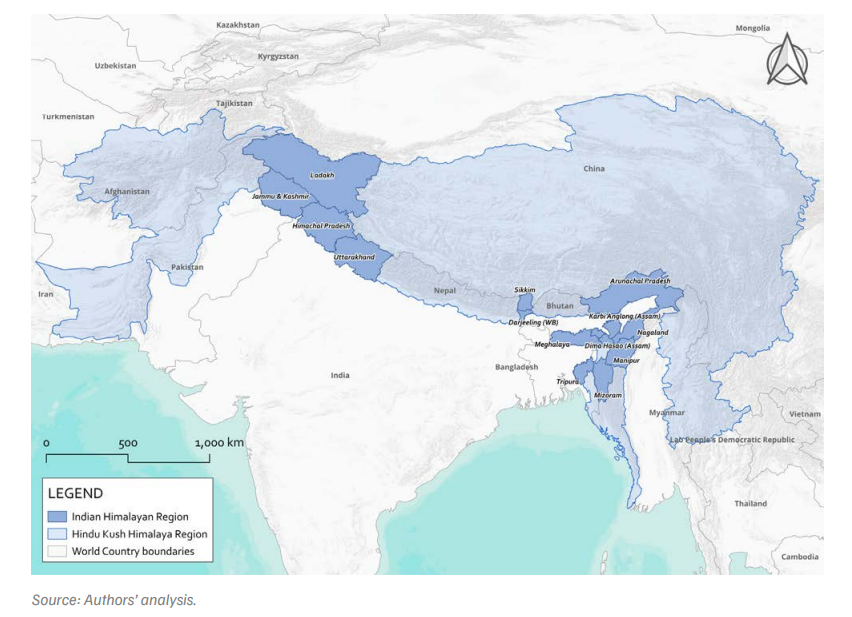
The Indian Himalayan Region (IHR) makes up 15 per cent of the HKH and faces these rising climatic and developmental risks. The IHR is undergoing rapid, largely unplanned and unregulated urbanisation (Walker 2011), marked by extensive land-use change (Sharma et al. 2022), encroachment into fragile ecological zones (Kumar et al. 2021), obstruction of natural water bodies, and slope cutting for road construction (Dennehy 2017). These rapid changes are straining critical ecological and infrastructural systems in the IHR, which contains some of the youngest and most geomorphologically sensitive folds of the Himalayas (Banerjee 2026). As a result, the region faces cascading physical and socio-economic risks from rising climate extremes. For instance, more than 14,390 landslides were recorded across the IHR between 2020 and 2024, disrupting road access, cutting off communities from critical services, and compounding existing infrastructural and livelihood vulnerabilities (CEEW 2025).
Within the IHR, Himachal Pradesh, in the western Himalayas, faces particularly high risk due to the combined impacts of rapid urbanisation, environmental degradation, and changing weather patterns (Tolani et al. 2024). Between 2020 and 2025, the state recorded cumulative damage of INR 21,097 crore (USD 2.19 billion) and the loss of more than 2,000 lives (HPSDMA 2025). Infrastructure, including road networks and education and healthcare facilities, was most affected, followed by key livelihood sectors. Satellite assessments also reveal a 10 per cent reduction in seasonal snow cover (IMD 2024), which has adversely impacted mountain agriculture and horticulture in a state where more than 60 per cent of the population depends on these sectors for household income (Wing et al. 2021). In response to these impacts, however, communities and institutions across Himachal Pradesh are taking active steps towards disaster risk reduction (DRR) and climate adaptation.
Local communities are best placed to lead both climate adaptation and disaster risk reduction (Soanes et al. 2021; Gupta et al. 2026) as they face long-term cascading socio-economic impacts of climate risks and are often the first responders during and immediately after extreme events, especially in remote mountain contexts. Having historically been exposed to such events, local communities in Himachal Pradesh demonstrate a high capacity for both climate adaptation in the long term and disaster risk reduction in the short term, with many adaptive practices culturally embedded and locally sustained for decades.
Recognising this opportunity, the Himachal Pradesh State Disaster Management Authority (HPSDMA) is taking active steps to strengthen disaster preparedness at the panchayat level and decentralise disaster response. Through the state’s Panchayat Emergency Response Centre Scheme, launched in 2025, it plans to institutionalise community-based disaster risk management (CBDRM) by establishing an organised, community-based framework for disaster preparedness, response, and recovery at the grassroots level, particularly during the critical hours immediately following a disaster, when external assistance may be delayed due to Himachal Pradesh's challenging terrain.
At the same time, communities across Himachal Pradesh are anticipating risks and taking action towards climate adaptation in the long-term (see fig ES3). Himachal Pradesh therefore presents a rare opportunity to demonstrate how anticipatory adaptation pathways can be co-developed by aligning strong community capacities with pioneering state-led institutions.
The study built an evidence base through a literature review and stakeholder consultations, then documented climate risks and existing adaptation solutions with communities across 12 gram panchayats in four districts. We then convened stakeholders in Shimla to collectively vision a climate-resilient future for each sector and used foresight tools to map the actions, actors and mechanisms needed to reach it (see Chapter 2).
All 12 gram panchayats surveyed are experiencing socio-economic impacts from a changing climate, as climate hazards combine with local development choices to amplify risk factors. However, all 12 Panchayats also demonstrate strong initiatives taken to reduce disaster risks and adapt in the long-term.
a. Socio-economic risks of a changing climate across 12 gram panchayats in Himachal Pradesh
b. Adaptation solutions for building climate resilience of Himalayan communities
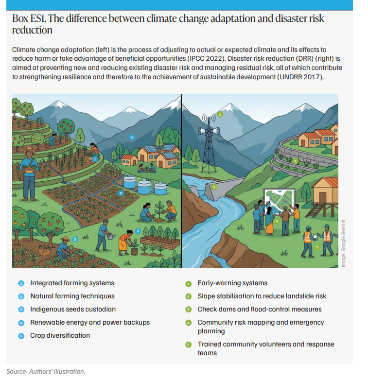
25 anticipatory adaptation solutions were co-identified across five critical sectors: mountain agriculture, water management (including domestic and agricultural), community-based disaster risk reduction (CBDRR), critical infrastructure, and development planning (see Figure ES3). These range from natural farming and a shift to climate-resilient crops in mountain agriculture, to rainwater harvesting and the rejuvenation of baoris and springs in water management, to the development of village-level disaster management committees, and relocating critical infrastructure to safe zones.
Figure ES3. What a climate-resilient Himalayan village looks like: visualisation of adaptation solutions
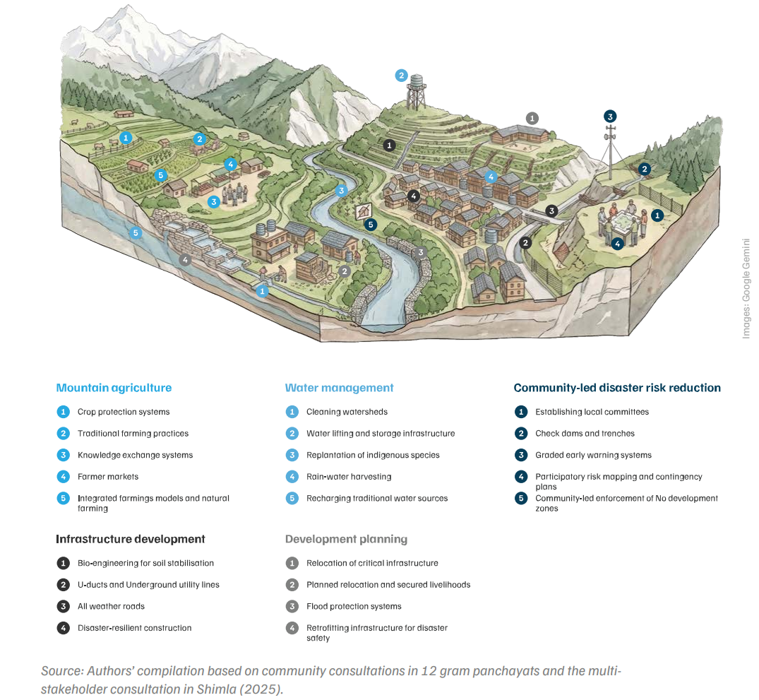
Figure ES4. Anticipatory adaptation pathway for community-led disaster risk reduction
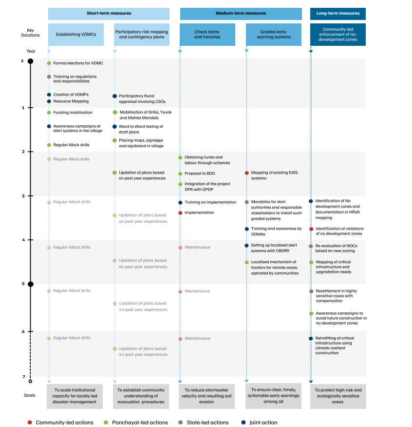
Figure ES5. Existing schemes and funds can finance anticipatory adaptation across five sectors
Consolidate integrated farming, adaptive cropping, and suitable livestock choices
Medium-termDiversify crops and livelihoods to reduce risk and stabilise incomes
Long-termBuild resilient infrastructure, local markets, and supportive institutions
Restore springsheds and undertake pre-monsoon watershed cleaning
Medium-termRestore rainwater harvesting systems and lifting
Long-termRestore ecology, replace chir pine, with community-led pine needle collection
Locally validate hazard maps and integrate risk into planning
Medium-termPlan relocation with land tenure security, services, and livelihood continuity
Long-termRestore vacated land as ecological buffers and steward it through local institutions
Tailor development control regulations for safer mountain growth
Medium-termRelocate critical facilities and scale bio-engineering solutions
Long-termUpgrade utilities, underground power lines, and enforce buffer/no-development zones
Form and train VDMCs across Panchayats with frontline workers
Medium-termImplement VDMPs and community-managed early warning systems
Long-termMake preparedness part of everyday governance through continuous risk monitoring
Source: Authors’ analysis.
Note: ATMA: Agricultural Technology Management Agency; CAMPA: Compensatory Afforestation Fund Management and Planning Authority; CSR: corporate social responsibility; DDMP: District disaster management plan; DM: disaster management; GPDP: gram panchayat development plan; HPPWD: Himachal Pradesh Public Works Department; HPRIDCL: Himachal Pradesh Road and Other Infrastructure Development Corporation Limited; HP-SRTP: State Roads Transformation Program; PK3Y: Prakritik Kheti Khushhal Kisan Yojana; PMAY: Pradhan Mantri Awas Yojana; PMGSY: Pradhan Mantri Gram Sadak Yojana; PMKSY: Pradhan Mantri Krishi Sinchayee Yojana; PPP: public–private partnership; PWD:Public Works Department; RAFTAAR: Remunerative Approaches for Agriculture and Allied Sector Rejuvenation; READY-HP: Resilient Action for Development and Disaster Recovery Project in Himachal Pradesh; RKVY: Rashtriya Krishi Vikas Yojana; SDRF: State Disaster Response Fund; VB-G RAM G: Viksit Bharat – Guarantee for Rozgar and Ajeevika Mission; VDMC: village disaster management committee, and VDMP: village disaster management plan.
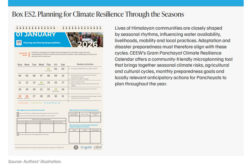
Positioned closest to communities, VDMCs can translate early warnings into anticipatory action by coordinating preparedness, last-mile response, and community mobilisation. Regular training, clear standard operating procedures (SOPs), and micro-planning tools such as the Gram Panchayat Climate Resilience Calendar, developed by CEEW, can help VDMCs anticipate risks and strengthen disaster preparedness as part of everyday local governance.
As the primary statutory instruments for village-level planning and budgeting, GPDPs provide a strong platform for mainstreaming climate adaptation into rural development. They can enable effective adaptation through cross-sectoral planning and coordination and by aligning local priorities with state and national missions and schemes.
A dedicated foresight cell could enable a systematic shift from reactive response to a more proactive approach by embedding anticipatory action and scenario-based planning into disaster preparedness and decision-making. Evidence from Nepal, Bangladesh, and Bhutan demonstrates that such institutional arrangements are both practical and effective (ICIMOD 2026).
Artificial intelligence (AI), machine learning, high-resolution geospatial analytics, and remote sensing could be leveraged to improve forecast precision and lead times and translate meteorological warnings into impact-based localised forecasts (IbFs). Such forecasts can enable VDMCs to pre-define anticipatory actions against set thresholds, helping to prevent damage and loss when disasters strike (IWMI 2025).
Disaster management authorities should adopt forecast-based financing models that release funds when pre-defined risk thresholds are reached. Forecast-based financing (FbF) can be integrated into state, district, and gram panchayat disaster management plans by defining triggers and action protocols and establishing decentralised contingency financing. This can support early actions such as pre-emptive evacuation, route clearance, and preparedness measures, potentially reducing losses (IFRC 2017).
Anticipatory adaptation is adaptation that takes place before the impacts of climate change are observed. In the Himalayas, extreme events are growing more frequent and often cut off remote villages, so communities are frequently the first responders. Preparing in advance, rather than reacting after a disaster, can reduce loss and damage and protect lives and livelihoods.
Strategic foresight uses participatory tools to explore possible futures, understand interconnected risks, and identify actions needed to achieve a climate-resilient future. The study demonstrates how this approach can connect community knowledge with institutional planning and decision-making.
The report examines how Himalayan communities can anticipate climate risks and adapt before those risks materialise. Using strategic foresight, it documents the climate risks and adaptation practices of communities across 12 gram panchayats in Himachal Pradesh. It then sets out pathways, built with communities and officials, to scale these practices into anticipatory adaptation across five sectors.
Himachal Pradesh faces high climate risk, but it also combines strong community knowledge with growing state support for decentralised disaster management. Through the Panchayat Emergency Response Centre Scheme, launched in 2025, the state is building community-based disaster risk management at the panchayat level. This makes it a strong setting to show how community capacity and state institutions can work together.
The report is intended for state and district disaster management authorities, rural development and line departments, gram panchayats, NGOs, funders and research institutions. The adaptation pathways presented and list of supporting schemes can help integrate suitable measures into gram panchayat development plans, district disaster management plans and panchayat-level preparedness plans.
Living with Heat in Bangladesh