Council on Energy, Environment and Water Integrated | International | Independent
Suggested citation: Mohanty, Abinash. 2020. Preparing India for Extreme Climate Events: Mapping Hotspots and Response Mechanisms. New Delhi: Council on Energy, Environment and Water.
The study is the first-of-its-kind district-level profiling of India’s extreme climate events such as cyclones, floods, and drought. It uses spatial and temporal modelling to develop the district-level assessment discussing the complexities and non-linear trends and patterns. Besides the frequency of climate catastrophes, it examines the pattern of associated events and how the impacts have compounded. Further, it analyses the shift in trend in climate events across sub-regions within the country. The study uses a pentad decadal analysis to develop an extreme climate events catalogue for a historical time scale of 50 years (1970-2019).
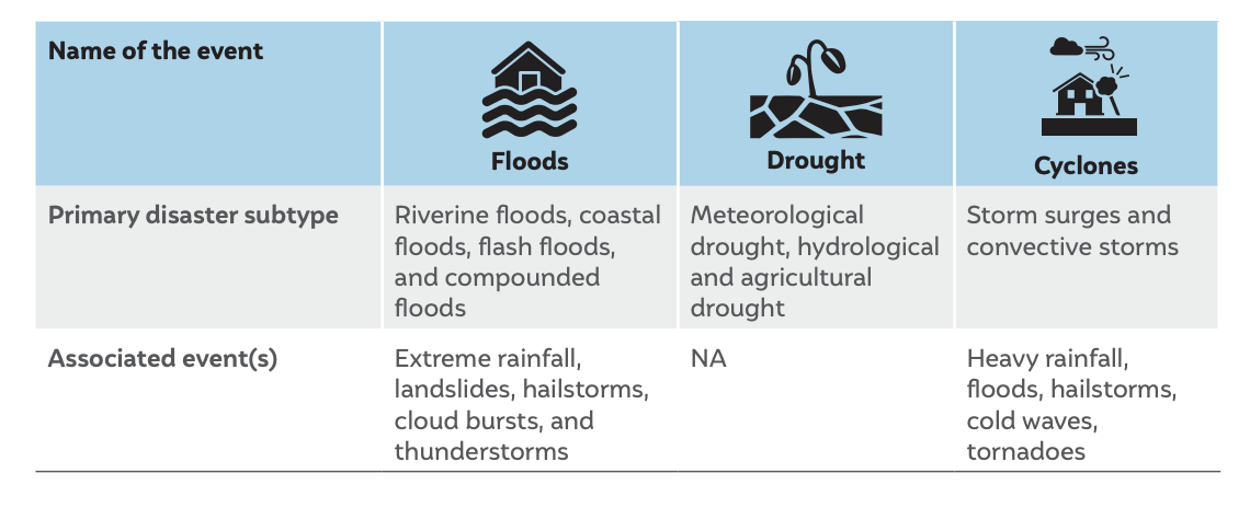
Classification of extreme climate events considered in this study
Climate change poses unprecedented challenges to human-made and natural ecosystems as well as to anthropocentric and economic activities. The most obvious evidence, arguably, is the surge in the frequency of extreme events. Extreme weather events resulting from climate change led to 495,000 human deaths across the world in 1999–2018. Further, more than 12,000 extreme weather events led to losses worth USD 3.54 trillion (measured in terms of purchasing power parity or PPP) during this period. Against this backdrop of changing climate, the frequency, intensity, spatial extent, duration, and pattern of weather and climate events are also changing, leading to unprecedented climate extremes (Zhai et al. 2018).
According to the Climate Risk Index, 2018, India jumped nine places in climate vulnerability rankings and was ranked the fifth-most climate-vulnerable country in the world (German Watch, 2018). Storms are escalating into cyclones, droughts are affecting more than half of the country, and floods of an unprecedented scale are causing catastrophic damage. There is no denying that the climate is changing – and fast.
Global, regional, national, and subnational climate actions are geared toward limiting any further increase in the earth’s temperature to 2 °C. However, we must also consider the consequences of this “target” temperature increase, given that the current trends in extreme events are the result of a 0.6 °C rise in the last 100 years (IMD 2019).
This report presents a micro-level hazard assessment of climate extremes in India. Through geospatial, temporal analysis, we provide a detailed assessment of the impact of extreme events at a district level. We use the pentad decadal analysis of extreme events in India (1970–2019) to identify district hotspots and climate change landscape for extreme events (see Figure ES1). The study argues that comprehensive risk assessments at the localised level are the need of the hour and should be undertaken for all districts in India. This study looks at the combined risk of hydro-met disasters and their compounded impacts. As per our analysis, the Indian subcontinent has witnessed more than 478 extreme events since 1970 and an acceleration in their frequency after 2005.
Figure ES1 More than 75 per cent of Indian districts are extreme climate event hotspots
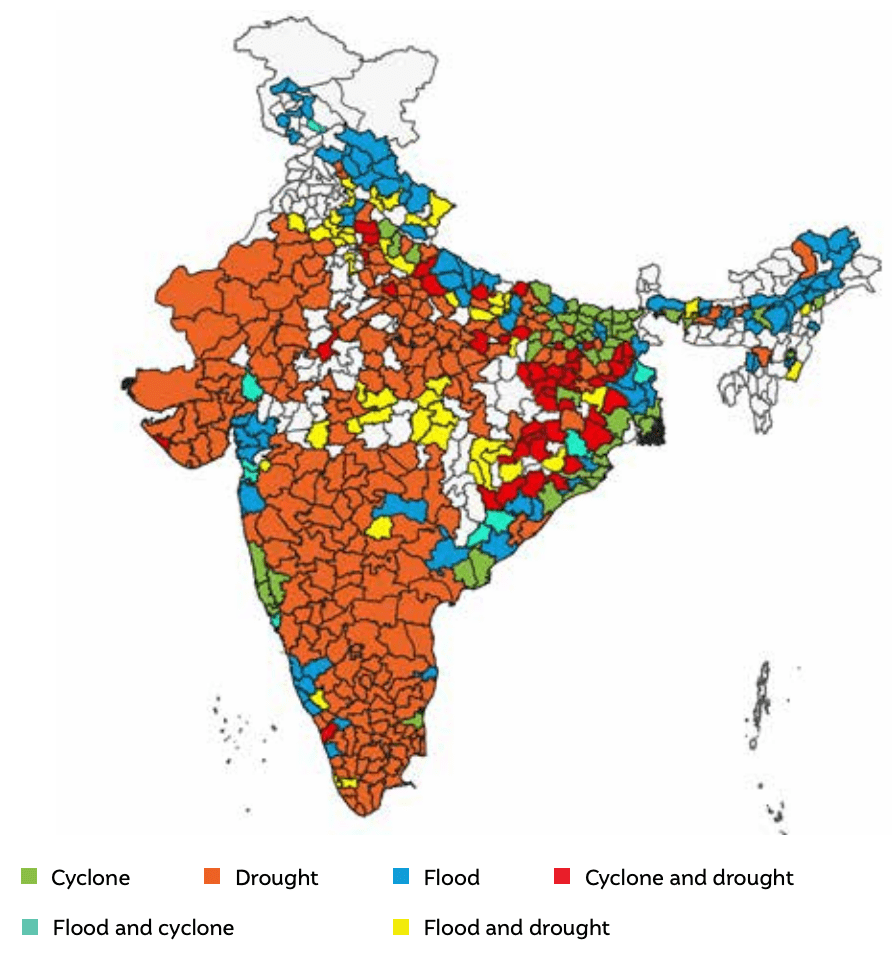
Source: Author’s analysis
According to our analysis, India experienced an exponential increase in extreme events during the period 1970–2019, with a marked acceleration in 2000–2019. We considered 2005 the reference year for the pentad decadal analysis primarily because of the availability of attribute base maps for 2005, which we procured from ISRO (Indian Space Research Organisation). However, this study focuses on only hydro-met disasters due to gaps in the data on other phenomena. We developed the district-level roster of extreme events for 1970–2019 in line with Emergency Events Database (EM-DAT) criteria and further updated it using data from the India Meteorological Department (IMD), National Disaster Management Authority (NDMA), Press Information Bureau (PIB), and the Ministry of Agriculture.
Our analysis found that floods and droughts have become increasingly common in many regions across various climatic zones in India. Figure ES1 indicates the districts that are extreme events hotspots in India. We infer that in the post-2005 period, at least 55 or more districts in India witnessed extreme flood events year-on-year (≈ 97.51 million people are exposed to extreme flood events in India annually). Increased precipitation levels are triggering a surge in extreme flood events, thereby causing severe damage to infrastructure and disrupting the socioeconomic fabric by causing extensive loss and damage to lives, livelihood and property. Similarly, 79 districts witnessed extreme drought events year-on-year (≈ 140.06 million people are exposed to extreme drought events), and 24 districts witnessed extreme cyclone events yearly (≈ 42.50 million people were exposed to storm surges, intense cyclones, and associated events). In the period 1970–2005, there were 250 extreme events; the post-2005 period witnessed 310 extreme and its associated events (which includes slow onset events like heat waves and cold waves). Frequent floods and droughts pose a severe challenge to food and water security in India. The empirical evidence generated from our analyses coincides with the weakening of monsoons due to rising micro-temperatures. This further can be validated by the fact that states like Maharashtra, Karnataka, and Uttar Pradesh saw severe water scarcity during 2015 due to record-breaking temperatures during summer and weakening monsoons.
We find that the pattern of extreme events is changing across some regions (districts) in India – some drought-prone districts are becoming flood-prone and vice versa. Rajkot, Surendranagar, Ajmer, Jodhpur, and Aurangabad, among others, are a few districts where we observed a shifting trend from floods to drought. A few districts in Bihar, Uttar Pradesh, Odisha, and Tamil Nadu observed the simultaneous occurrence of drought and floods. The trends are alarming and demand a comprehensive risk assessment at the local level, which requires a grid-level climatological analysis to identify the compounded impacts.
Our analysis reveals that microclimatic1 zones are shifting across various regions (districts) in India. The microclimate zones, categorised according to the Köppen-Geiger classification, are shifting due to climate change. It is important to note that a shift in microclimate zones may lead to severe disruptions across sectors. For instance, every 2°C rise in annual mean temperature will reduce agricultural productivity by 15–20 per cent. Flood- and cycloneprone districts fall under the category Cwa (monsoon-influenced humid subtropical climate), and drought-prone districts under Bsh (hot semi-arid climate). The flood-based climatic zones are shifting towards Aw tropical, which is characterised by its dry season, thus validating empirically that flood-prone areas are becoming drought-prone. On the one hand, cyclone hot spots are changing from Cwa to Aw tropical climatic zones; on the other, the urban heat island (UHI) effect and increase in sea level are pushing cyclonic disturbances towards warmer regions, as is evident from the climate zone shift. Drought events are becoming more intense, and empirical evidence from the analysis suggests that southern, western, and some parts of central India are becoming increasingly prone to drought.
While the frequency and intensity of extreme events are increasing, we are left with less than a decade to adhere to the Sendai Framework; course correction and policy implementation need to have a razor-sharp focus on curtailing the compounded impacts of climate change. Principles of risk assessment must form the core of India’s strategy to build resilience. While actions at the global, national, and subnational levels are targeting a well below 2°C limit, it is imperative to outline the chronic challenges that these extreme events pose, especially to the vulnerable sections and sectors. Extreme events are devastating since they are non-linear and disrupt natural and human-made ecosystems. Our analysis suggests some key recommendations that can trigger efforts towards a resilient pathway. Some of them are developing a comprehensive climate risk atlas, mainstreaming climate risk assessments at all levels across sectors; bridging financing gaps through innovative risk financing instruments; and enhancing resilience and adaptive capacity, among others. It is time to rethink and reorient our approach to mitigate disaster risks and prepare better for the impending climate uncertainties.
India is one of the most vulnerable countries globally, and its exposure to climate change impacts is increasing by the year. Our analysis suggests that more than 575 districts in India are exposed to compounded impacts of hydro-met disasters. This study provides evidence of changing climate at the district level by highlighting the morphology of extreme climate events through the analysis of historical time series. One key learning from this study is that the traditional approach of vulnerability assessments needs to be enhanced for a comprehensive risk assessment. Adhering to the principles of risk assessment remains central to any risk-assessment process, and it should be applied to the broadest possible extent (CEEW 2015). This should help us understand the segments of risk assessment – hazard assessment, vulnerability assessment, and compounded events assessment – in detail (Omar et.al 2014). For example, until now, most discussions of extreme climate events did not include the mapping of associated events and processes that compound the effects. The key recommendations from our work focus on five aspects: developing a climate risk atlas; developing an integrated emergency surveillance system; mainstreaming risk assessment; enhancing the adaptive and resilience capacity; increasing the participatory engagement of all stakeholders in the risk-assessment process; and integrating local, subnational, and national plans.
Our hazard assessment study clearly demonstrates that identifying the combined risks at a high resolution would enhance preparedness and enable climate-proofing of policies and plans. Our analysis further suggests that post 2005 more than 310 extreme events and its associated events have caused devastating impacts and it is important to project the climate risks in short term time scale. The climate risk atlas (CRA) will provide a base to understand, identify, and quantify hazards arising from specific climate risks across various sectors and elements through risk metric modelling, thereby generating evidence to build resilient communities, countries, and regions in a short term time scale which considers micro climatological assessments as well. The CRA will be a risk-informed decision-making toolkit on the cloud computing interface along with dynamically analysed high-resolution maps. It will help quantify the impacts of climate risks through downscaled risk rating indices for various sectors. The CRA will further help in climate-proofing the critical, emergency, transportation, and allied sectoral infrastructures.
Effective preparedness is a long-term, integrated, and multifaceted approach to disaster and emergency management. It strengthens governance frameworks and community preparedness, and systematically builds resilience and adaptation (CEEW 2020). Our analysis suggests that more than 80 per cent of Indian sub-continent is exposed to hydromet disasters and hence its surveillance is imperative. The hazard assessment can further supplement the development of a nationwide, centralised, structured, and real-time digital disaster/ emergency surveillance and management system. The Ministry of Home Affairs could scale up the basic surveillance and tracking system of the national Integrated Disease Surveillance Programme (IDSP) database and the state disaster management authorities (SDMA) to serve the entire range of emergency preparedness activities in the nation, which can be supplemented by both vulnerability and hazard assessment outputs.
As we highlighted earlier, climatological or meteorological studies need to have continuous, validated, and high-resolution historical data to undertake comprehensive risk assessments. A risk assessment helps us to set a limit to preparedness. While risks are uncertain, the preparation can be certain and well in the ambit of collective action to reduce possible damage. Risk assessments need to have a razor-sharp focus on some of the direct, indirect, transitional, and emerging risks that both chronic and non-chronic hazards pose to the most vulnerable communities and sectors. The first step of any risk assessment is risk identification, i.e., identifying the risks at a localised, regional, sectoral, and cross-sectoral level. Risk identification should also focus on the extent of loss and damage at the secondary (agricultural and labour productivity, industrial value, forced migration, and damage to biodiversity, the ecosystem, etc.) and tertiary (revenue and conflicts due to resource scarcity) levels. Risk assessments at the least possible downscaled level should have a description of the common language of the problem. Risk identification needs to inculcate climatological and meteorological processes at both the macro and microclimate levels, through loss precedence curve identification for each hazard and region.
Our analysis suggests that the micro climatic zone shifting trend, impending that drought prone areas are becoming flood prone and vice–verse. This changing pattern would require an enhanced adaptive and resilience capacity to climate proof lives, livelihoods and investments. There is limited capacity at the implementation level of disaster risk reduction plans. The approach by which we build adaptive and resilience capacity should be based on what we know, what can happen, and what can be done. Appropriate standard operating procedures (SOPs) should be formulated and strictly enforced in planning and designing. These should be coupled with operational training at the grassroot level to enhance resilience. The state- and district-level disaster plans list various training and capacitybuilding programmes. The mainstreaming of disaster risk reduction in developmental project planning can mitigate loss and damage if matched with high-resolution exposure assessment. This adaptive capacity training should not just be focused on government functionaries but also on masons, architects, designers, and other relevant frontline stakeholders.
A global study on risk assessment by CEEW in 2015 highlighted the importance of participatory engagement, and this engagement holds the key to building resilience. Any risk assessment should include policy and decision-makers right from the inception of the process, thereby ensuring that problems are identified and solutions are feasible. (CEEW 2015). The ambit of risk assessments should involve public policy, economic, insurance, and industry partners, apart from climate scientists, who have a core mandate of risk-informed planning at different levels. Often, the risk-assessment process tends to marginalise the those affected by climatic shifts. The communities might not have scientific expertise, but they embody traditional management practices, and these are low-hanging fruits that can be harnessed at the community level with less financial implications. Mitigation, adaptation, and resilience-building efforts should not work in silos; instead, the approach should be to understand the co-benefits of mitigation and adaptation. The inclusion of co-benefits and hazard sensitivity functions in long- and short-term risk projections can fetch better results.
As we are approaching the completion of the first phase of the Sendai Framework, it is essential to understand that dedicated plans, while important, have often led to duplication in terms of work and financial allocation. In India, the plans range from national disaster plans to the state and district disaster plans from a DRR purview. Similarly, for climate actions, we have the NAPCC (National Action Plan on Climate Change) at the national level and the SAPCC (State Action Plan on Climate Change) at the state level. Our analysis further suggests that more than 1.0921 billion people are currently exposed to extreme and its associated climate events. The plans don’t consider national level or state level risk assessments during its planning nor implementation (Mcbean et.al 2012). These plans needs to mainstreamed and integrated at all levels. All of these plans look at mitigating risks and building resilience with a different set of actors and parameters. Further mitigating loss and damage calls for an integrated approach, where there should be convergence across actions, and the standards for evaluating them should be the same. The integrated approach should include both sectoral and socioeconomic indicators.
Roadmap of the methodology to assess the climate co-benefits of the SUP ban in Tamil Nadu
Unlocking finance for NbS in Indian Cities
Locally-led Climate Action in the Global South
Towards Climate-resilient Indian Industries:
Roadmap of the methodology to assess the climate co-benefits of the SUP ban in Maharashtra